Carlsbad Caverns, located in southeastern New Mexico, is a remarkable underground wonderland carved from ancient limestone. This national park showcases a unique geography shaped by millions of years of geological processes. From its intricate cave systems to the surrounding Chihuahuan Desert landscape, Carlsbad Caverns offers a fascinating glimpse into the Earth’s geological history and the ongoing forces that continue to shape this subterranean world.
What is the Location and Elevation of Carlsbad Caverns?

Carlsbad Caverns National Park is situated in the Guadalupe Mountains of southeastern New Mexico, USA. The caverns themselves are found at an elevation ranging from approximately 3,500 to 4,000 feet (1,067 to 1,219 meters) above sea level. This location places the caverns within a unique transitional zone between the desert floor and the mountain ecosystems.
How Were the Rock Layers and Formations Created?

The geological story of Carlsbad Caverns begins with the Capitan Limestone, a Permian-aged rock formation that forms part of the larger Capitan Reef complex. This ancient reef, dating back about 265 million years, is one of the best-preserved fossil reefs from the Permian period.
Unlike many limestone caves formed by carbonic acid, Carlsbad Caverns was primarily sculpted by sulfuric acid. This unusual process occurred as follows:
- Hydrogen sulfide gas from nearby oil fields rose through cracks in the limestone.
- The gas mixed with oxygen-rich groundwater, forming sulfuric acid.
- This potent acid dissolved the limestone, creating the vast chambers and passages we see today.
What is the Climate Like at Carlsbad Caverns?
The climate of Carlsbad Caverns National Park is characterized by the arid conditions typical of the Chihuahuan Desert. Here’s a breakdown of the key climate features:
| Climate Factor | Description |
|---|---|
| Average Annual Temperature | 56°F (13°C) to 78°F (25°C) |
| Humidity | Low |
| Annual Precipitation | Approximately 15 inches (381 mm) |
| Seasonal Variations | Significant differences between winter and summer temperatures |
This desert climate plays a crucial role in shaping both the surface landscape and the conditions within the caves.
What Are the Major Landforms in and Around Carlsbad Caverns?
The geography of Carlsbad Caverns National Park is defined by several distinctive landforms:
-
Guadalupe Escarpment: This prominent mountain range trends northeast to southwest and includes the Carlsbad Ridge where the caverns are located. The escarpment is composed of Upper Permian reefal and perireefal limestones.
-
Caves and Sinkholes: The park is home to over 119 known caves, with Carlsbad Cavern being the most famous. These underground chambers and passages were formed through the dissolution of limestone by sulfuric acid. The natural entrance to Carlsbad Cavern was created by a collapse at the cave’s top and subsequent surface erosion.
-
Ridges and Canyons: The area features deep canyons that cut through the Guadalupe Mountains landscape. Notable examples include:
- Dark Canyon
- Rattlesnake Canyon
- Slaughter Canyon
These canyons provide insight into the area’s geological layers and contribute to the park’s diverse topography.
What Surface Features Characterize the Carlsbad Caverns Area?
The surface geography of Carlsbad Caverns National Park is as intriguing as its underground features:
Vegetation
The park’s surface is dominated by Chihuahuan Desert vegetation, including:
- Desert shrubs
- Various cacti species
- Drought-resistant grasses
In the higher elevations of the Guadalupe Mountains, visitors can observe forested slopes, creating a stark contrast to the desert below.
Soil Composition
The soil in the Carlsbad Caverns area is generally:
- Thin and poorly developed due to arid conditions
- More substantial in valleys and basins, but still relatively sparse
- Reflective of the desert environment, with limited organic content
How Does Water Influence the Geography of Carlsbad Caverns?
Water plays a vital role in shaping the geography of Carlsbad Caverns, both on the surface and underground:
-
Surface Erosion: Rainwater and snowmelt contribute to the erosion of the limestone landscape, gradually reshaping the surface topography.
-
Cave Formation: Water seeping through the limestone continues to dissolve the rock, albeit at a much slower rate than the initial sulfuric acid dissolution.
-
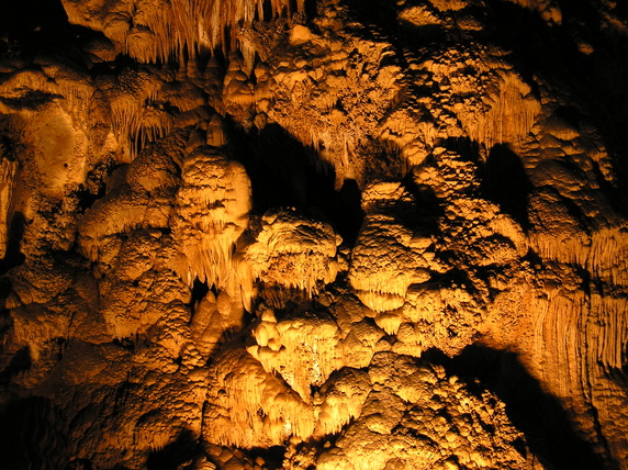
Speleothem Creation: Dripping water inside the caves deposits minerals, forming spectacular formations such as:
- Stalactites
- Stalagmites
- Flowstones
-
Draperies
-
Hydrological Cycle: The limited surface water in this arid region makes the underground water resources particularly important for local ecosystems.
What Ongoing Geologic Processes Shape Carlsbad Caverns?
The geography of Carlsbad Caverns continues to evolve through various geologic processes:
-
Local Faulting: Tectonic activity in the region can cause shifts in the rock layers, potentially creating new pathways for water and affecting cave development.
-
Uplift: The gradual uplift of the Guadalupe Mountains exposes more of the ancient reef limestones to the surface, influencing both surface and subsurface geography.
-
Erosion: Continuous erosion by wind and water sculpts the surface landscape and can expose new cave entrances or alter existing ones.
-
Mineral Deposition: The ongoing process of mineral-rich water seeping through the caves leads to the growth of speleothems, constantly changing the cave’s interior geography.
-
Microbiological Activity: Recent studies have shown that microorganisms play a role in cave formation and the creation of certain mineral deposits, adding another layer to the complex geologic processes at work.
The geography of Carlsbad Caverns is a testament to the power of geological processes over vast spans of time. From the ancient sea that deposited the original limestone to the ongoing formation of delicate cave structures, the park offers a unique window into Earth’s geological history and the dynamic forces that continue to shape our planet.
